 There is a new show this season that recreated in a very special mysterious way the story of a high security prison that became a legend. And since this can be interesting to learn more about it, I asked well renowned geologist Graciela Argüello from the Geological Blog “Crazy About Geology”, and BTW AKA My Mom.
I asked her to tell me more about the geological history of the Alcatraz island where the former prison is located, which is very exciting as well as the stories that JJ Abrams and his team will tell us.
First of all, I want to state that as the intention of this blog is not in the least to become a Geology handbook, the topics are not didactically ordered, (although in a very subtle way I establish a sequence along some subjects) but rather selected in order to surprise the readers with something interesting though unexpected.
Where is the former prison of Alcatraz located?
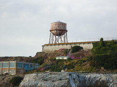
It lies on the West coast of United States, inside San Francisco Bay, in one of the many Islands that can be found there, more specifically the so-called Alcatraz Island, also known as The Rock.
 The island name was chosen by its discoverer, the Spanish Juan Manuel de Ayala, who in 1755 named it so, supposedly because of the abundance of such birds. It is interesting though that when one seeks information on the present bird population of the island, the alcatraz is not found. There are instead abundant gulls (genus Larus) and the question is whether since the time of Spanish colonization, the alcaltraces (genus Morus) disappeared from the island, or they never lived there and the whole thing rests on a wrong classification of the birds at the moment of the first descriptions.
What are the main features of San Francisco Bay?
It is a complex system of small estuaries that are connected to each other and drain almost half of the superficial waters of California. The main rivers -Sacramento and San Joaquin- flow downwards from Sierra Nevada. The total area of the Bay is approximately 568 square kilo-meters, and its boundaries both at the East and West are two branches of the Coast Range mountains trending NW-SE. Two major systems of faults are also particularly interesting in the system: the ineffable and well known San Andreas Fault at the West, and Hayward Fault at the East. Obviously the orographic (ranges) and structural (faults) systems are genetically related.
What is the geological setting of Alcatraz Island?
The whole San Francisco Bay is located on a complex of rocks called Franciscan, because they formed in a homonymous ancient subduction zone that existed since early Cretaceous (a period that stretched from about 125 to 60 million years ago).
The plates configuration has changed since then, and so did the relative movements between them, so that today we will not find them with that name nor equal dynamic, but in the Cretaceous, the plate called Farallon, dense and dark- because it was constituted by oceanic crust- sank eastwards under the North-american plate until its complete disappearance.
At that time, of course, the oceanic space that today is San Francisco Bay did not exist, and neither did the Coast Range. There was only the great trench that subducted Farallon plate (R.I.P.).
At the end of this subduction the uplift that gave birth to the mountains of California took place, but please notice that we are talking about processes that lasted hundreds of thousands, or even millions of years each.
After the uplift and its resulting superficial erosion, the ancient Franciscan rocks were again exposed on certain points of the surface. But most of them are still underlying San Francisco City.
What kind of rocks are those of Alcatraz Island?
Due to an interesting reason that is to be explained a little further down, the Bay has a fairly heterogeneous composition where sedimentary rocks of different types (the most abundant) coexist with some igneous (up to 10 percent of the material) and just to complete the picture, also low degree metamorphic rocks are present. That means that nothing is lacking.
However, on the island of Alcatraz, specifically, the Petrology is relatively uniform, since it is a terrane (a term that I will explain some lines ahead) of early Cretaceous age composed of a type of sandstone known as greywacke that typically contains a lot of feldspar and little quartz, which is interpreted as mineralogical immaturity. (Nice topics for future posts)
These rocks are arranged in very thick layers that through erosion build the characteristic hills of San Francisco downtown.
What are the terranes?
If you believe that the movements are graceful slides resembling a rock ballet, you are completely wrong, and to confirm what I say it should be enough to take into consideration the violent earthquakes that these restless portions of the crust are able to cause.
Thus, many times, in their eagerness to accommodate, some pieces- bigger or smaller- are torn apart from the plate to which they belong, and travel on their own to a new location in this puzzle on top of which we are sitting while we talk about this and other tiny details. Those pieces of ancient plates are named terranes.
A terrane can therefore be significantly different in structure and lithology of all adjacent areas, and sometimes its parental plate cannot be recognized. Most of the times, indeed.
Eventually, the terranes can be in convergent areas where collisions between plates occur, and they can become part of any of them, forming that beautiful patchwork that mostly constitutes the continents that we know nowadays.
California itself is the result of such a “patching” of several terranes that got tired of touring and settled down there over the last few hundreds of millions years. Sonomia for example, would have been added about 375 million years ago, Smartville, more or less 225 million of years ago, and the Franciscan rocks that began to join North America over the last 175 million years, are in turn a collection of smaller terranes.
Let´s not complicate the subject any more for the moment. The point is already clear enough, or at least I think so.
How can we summarize the geological history of the island of Alcatraz?
Research has made it possible to build a model of how the island would have evolved since Jurassic times, that is about 200 million years ago, when the Pacific Ocean was different from the present one. At that time, the western edge of the North American plate would have been about 100 or more miles to the East of its present position, and there was a subduction zone towards which the old Pacific plate was drifting.
Also other numerous terranes were moving towards this subduction zone, on an old version of the Farallon plate that I have already mentioned.
These terranes piled up underneath the edge of the American plate which was extending to its modern configuration.
At some point, this subduction zone was closed and a new one was opening to the west. Towards this new subduction zone the Farallon plate (in its new configuration) is still moving. This subduction is the Franciscan area where the homonymous rocks were formed.
As it was already said, Farallon plate was finally completely subducted under the American plate, and therefore returned to the Earth’s mantle (area below the crust). The Alcatraz terrane was in the middle of this mess.
At the same time many other things happened, as for instance, magmas generation, metamorphism, and so on, but because of the length of this post, I will only tell you a few things about the little island that is the subject today.
By the end of the Cretaceous period the uplift of the Ranges and its consequent erosion begin. The configuration of the Coast Range begins during the Tertiary period, exposing again the Franciscan rocks that once were deeply buried. By then, also the faults system is already formed.
Although the uplift of most of the ranges continued during the Quaternary period, there were also areas which sank around San Francisco Bay, and the Pacific Ocean invaded them. Alcatraz Island is nothing but the top of an ancient hill that was submerged at that time. From then on, the Bay was alternatively emptied or filled depending on the glacier surges and regressions that in turn determined more or less available water in the sea.
This explains the dunes that can be seen in Northern San Francisco and are no other thing than the sands deposited by Sacramento River when the sea level was so low that the coastline was tens of kilometers to the West of the present coast. The wind was then able to transport them inside the continent.
This post is quite extensive, but do not believe that we have exhausted all related issues, on the contrary, there is still more to talk, and you can ask away in the Geological Blog, or here in the comments.
Post Author: Graciela Argüello.
References:
Carlson, P.; Chin, J.; Wong, D. 2000. Bedrock Knobs, San Francisco Bay. Do navigation hazards overweight other environmental problems? Environmental Engineering Geoscience. Vol. VI No. 1, February pp 41-55.
Konigsmark, T. Geologic Trips. San Francisco and the Bay Area 2006. Third Edition. Geopress. I.S.B.N. 09-661316-4-9 175 pp.
If you have liked this post well enough to take it to your blog, or to upload it into the social network, please, mention the source.
You can also read my coverage on Alcatraz, or follow me on Twitter for more Alcatraz scoop.
 Follow

homonymous rocks? Mentioned twice. I couldn’t find a specific definition. I concluded it meant that the rocks are given one name even though they are not identical.
Yes Good story, but least Geology. From the title I was expecting Geology. All read here is a submerged hill!. Sorry. I see that Alcatraz is a surface remnant of an acretionary prism, accumulated due to the subduction of Faralon oceanic plate below North American continent, not sure on time-scale.
I was there last week, on a tourist trip to Alcatraz, and was very curious on Geology, on the road cut while going up. I took a picture. I am just curious on finding the geology, like I do in any other tourist spot that I go to.
The beds are very steeply dipping (Probably SW~70 degrees, no measurement, just a hunch. These are very coarse grained sandstones (probably Feldspathic Quartites. (seems right in this story). Certainly these are turbidites and well bedded and laminated, alternating with 1-2ft shales, rhythemically at regular intervals! These are slope deposits of developoing acretionary prism. I will post some more when I find.